ADK 46: Nippletop/Dial (+ a bonus)
September 18, 2020 | Keene Valley, NY
The background: As part of my ADK 46-er journey (climbing all the 46 High Peaks of the Adirondacks) Dial and Nippletop were the next 2 peaks on my radar for this trip. I had been waiting for a weekday to tackle these, and so this particular Friday in September was looking like the one. This would be another solo hike for me, which I don’t mind, but I wanted to ensure the weather and other logistics were looking mostly in my favor for whichever day I chose. This would not be my first time in this section of the High Peaks Wilderness, so I truly felt like I had a good grasp on what the day would include, as well as a handle on mitigating potential risk as much as possible. Read on to find out how they day went! (Spoiler alert: it was an almost near-perfect hike in the ADK for me, which is very rare!)
I will write much more extensively on the Adirondack 46-er High Peaks in future posts, but in the meantime, you can read more about it here.
Getting there: From exit 30 off I-87, turn left onto NY-73 west, for about 5.5 miles; the official trail parking area will be on your left. You’ll turn left down Ausable Road, where the lot is immediately on the left-hand side (if you reach St. Hubert’s Road, you’ve gone too far down 73.) There is not really a sign designating the lot, so you’ll have to be on the lookout for the turn in. There are also a few spots across the street at the Roaring Brook trailhead, as well as roadside (be careful crossing!)
Important note: As of 2020, parking is extremely limited due to part of the lot being closed. This smaller lot will fill up quickly, sometimes as early as 4AM on weekends –have a backup plan (or 2) in mind.
The route: This is a 15-mile hike with at least 4,000 feet of elevation gain; my route was counter-clockwise from Lake Road/Gillbrook cut-off to Indian Head, up Elk Pass to Nippletop, then to the H.G. Leach trail over Dial and Bear Den, to loop back to Lake Road. Phew!
Note: this trail crosses over both private property (the Adirondack Mountain Reserve AKA AMR) and state land –there is an easement agreement with the state, so hikers are permitted; however, no dogs are allowed on this route that I describe below, since the approach starts from the AMR property. You also cannot camp on AMR property.
Indian Head
Real talk: I was sworried about the parking lot situation based on everything I was “reading and hearing” those days, so I aimed to be in the lot no later than 5 AM on that Friday in mid-September. The sun didn’t rise until a bit later, and I wanted to keep my walk in the darkness to a minimum, if possible. I arrived almost at exactly 5, not the first car in the lot, but also certainly not the last [let’s out sigh of relief.] A few minutes after as I was nibbling on some breakfast and gearing up, the cars started to trickle in. I decided that I would make the road walk in the dark, so set out around 5:20 with my headlamp and backup batteries. This was not my first time down to Lake Road, so I felt comfortable enough to start out in the dark. But I was still nervous – I tried not to let my fear get in the way; however, once I was in a good rhythm, it proved to be a peaceful experience amongst the moonlit forest road. I also had the comfort of knowing people would be starting their treks not too far behind me.
I will also note something different I did this trip: I started out wearing very light sneakers and carrying my boots – this was to save my feet during the long portion of road walking in less-bulkier, more comfortable footwear (for me, that is.) More on that below.
If you’ve never hiked here before, you are about to enter the area of a country club (the Ausable Club) with quite a few amenities. I was very confused during my first hike in 2018, but after some quick Googling thereafter, it made a little more sense. You’ll be on private property until you see the sign that says you are on state land (depending which trail you are about to go on.) I passed the Noonmark trail register to the left, then approached the golf course to my right, and continued to make my way to sign in at the trail register. It appeared there were a few hikers who signed in mere minutes before I had, giving me, again, some sense that I was not alone. I started the trek down the road (yes this is a road that cars drive down…) eagerly waiting for the sun to rise, but still enjoying the strange comfort (I guess you can call it that?) of dusk. The colors of dusk are magnificent in the mountains – there is no doubting this. I decided to make the trek down Lake Road until the Gill Brook cut-off (on the left) and bypass the Gill Brook trail earlier, as I was curious to take a different route than I had in the past. It was 6:55 at this point, and I had not seen a single soul, just one truck that drove down the road. It was here I changed into my hiking boots and tucked my sneakers in my pack. Time to start climbing.
Since I had gotten prettttty lost going to Indian Head back in 2018 (but somehow made it with some fellow hikers’ help), this was my first time going the proper way and with a plan. I followed the signs through the peaceful woods, steadily making my approach to one of the most famous ADK views. After the 0.4 miles through this section, I made a right and followed the signs to Indian Head. Nearly 20 minutes later, I was there – basking in all her glory, with a few other groups at the summit. I decided to fuel up and hydrate here, not wanting to lose steam or feel ill, as I had a full day still ahead of me. It was also a chilly day, so I had to keep moving.


Next stop: Nippletop Mountain
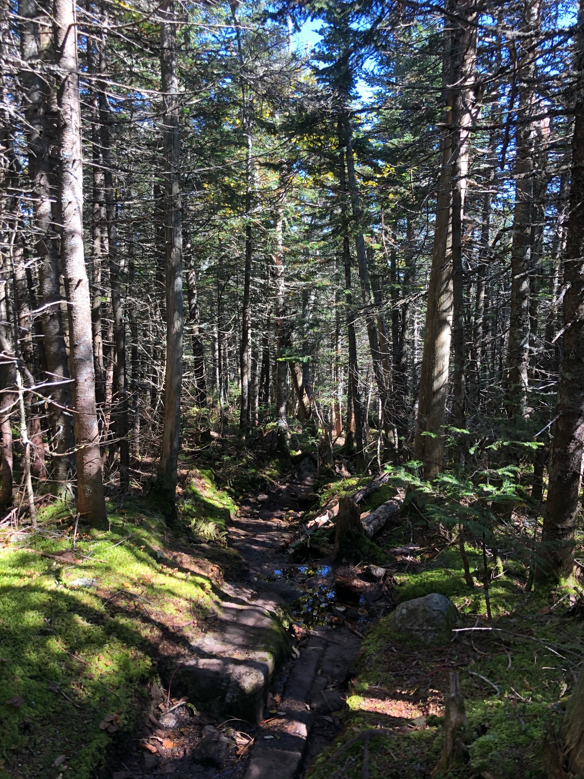
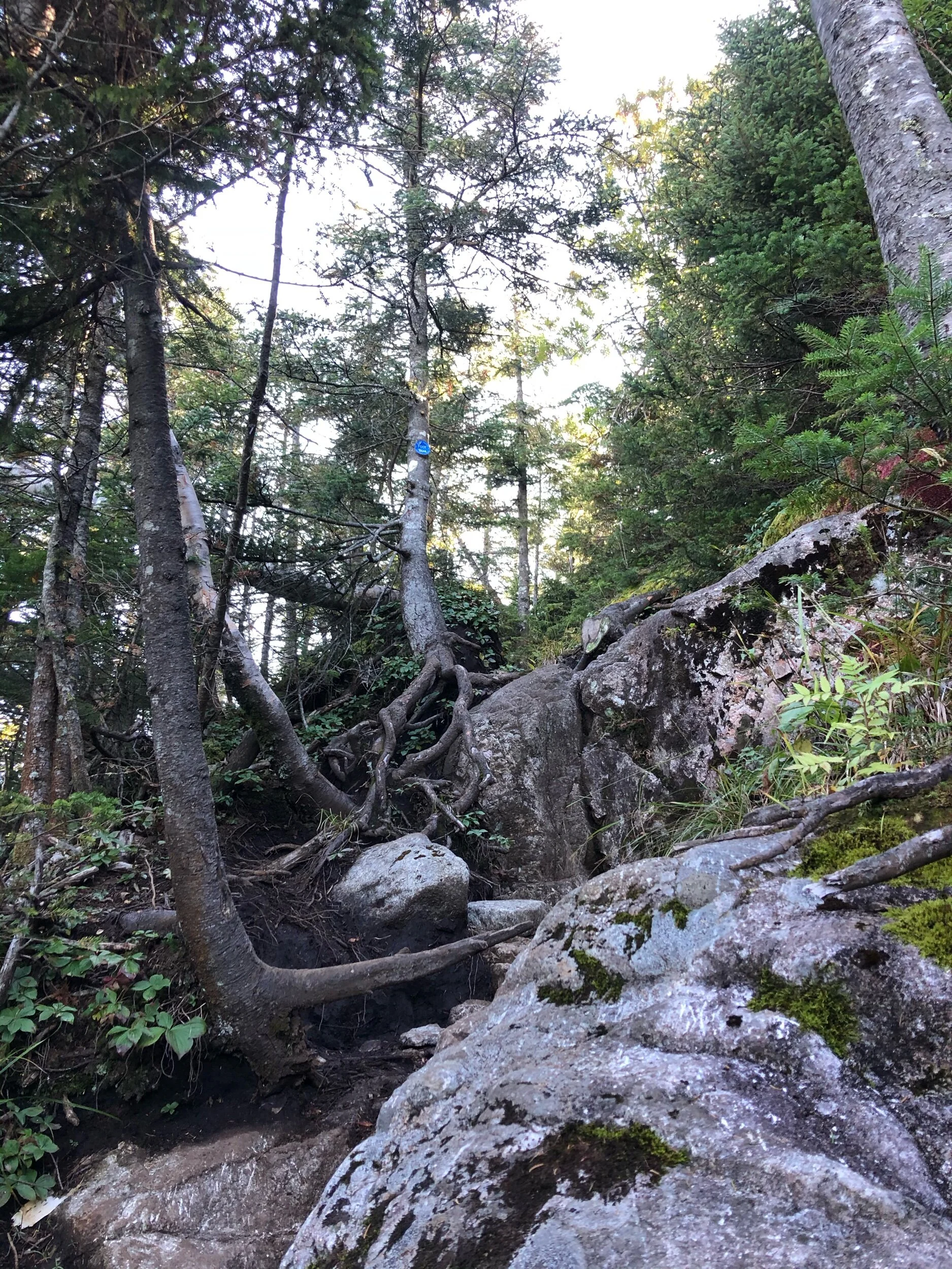
I decided to continue the 0.2 miles on the Fish Hawk Cliff trail, and then take the 0.4-mile trail to meet back up with the Gill Brook trail. Quickly after, I had reached the sign that indicated I was now heading into state land. I had been on this route before when hiking 2 other 46’ers, Colvin and Blake, so nothing was new or surprising to me on this trail section. I passed a group of 3 guys who were on their way to Colvin and Blake for the day, but otherwise, it seemed to be a rather quiet Friday in the wilderness. Steadily in no time, I reached the trail sign that pointed me in the direction of Nippletop – AKA the blue trail to Elk Pass (if you veer right, the red trail leads you to Colvin and Blake.) This is the section of trail I was highly anticipating – a 1.9 trek on steep, rugged terrain. I took a break and was greeted by a chipmunk looking for some breakfast – I wish I could have hung out more, but it was go-time. This section became muddy but wasn’t steep – yet. Be cautious when you walk over the planks – some were not in place! I continued, still waiting for the trail to get “miserable” but instead came across a few ponds and designated camp sites. The sky was miraculously blue, and it was turning out to be a gorgeous day. Shortly after, as I was starting to question Elk Pass’s misery, the climbing started. Lots of roots and steeeeep rocks to navigate, but nothing I found technically challenging or impossible to navigate alone. A few solo hikers had passed me on their descent as I climbed up. I was very glad I chose this counterclockwise route, as I would much rather ascend steep than descend it (to each their own though.) I kept stopping at times so I could look back and wow – the views kept getting better and better!
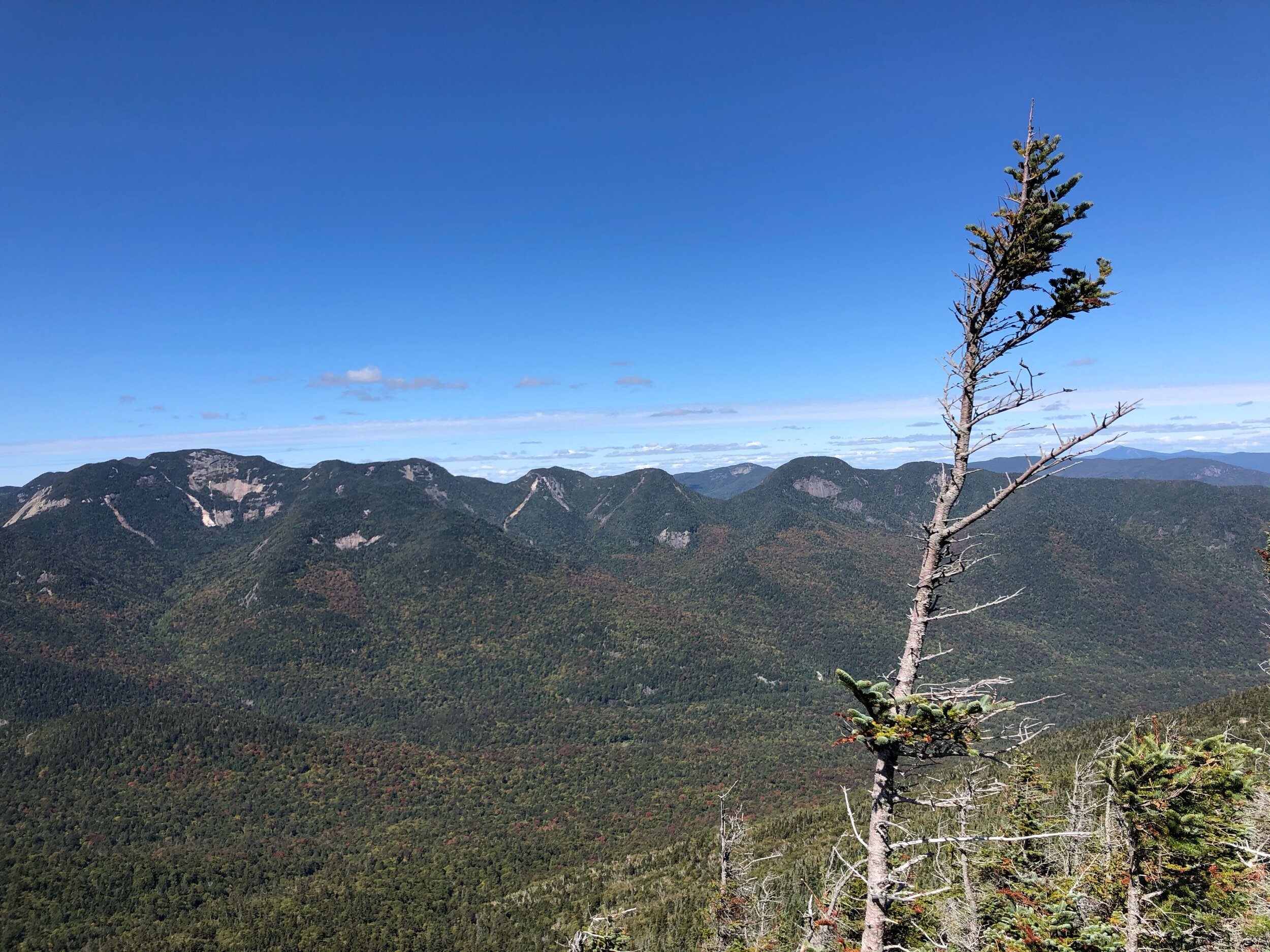
After what seemed like almost forever, I finally came across the next sign I had been looking for – 0.2 miles right to Nippletop. I had successfully made it up Elk Pass – the rest of the day should be a little bit easier and fun – we’ll see though. I made my way to the summit, where a few other hikers were taking in the view. I chatted with two women from the Finger Lakes region about our 46-journeys. The only thing I love more than hiking is talking or writing about hiking. There is a great view of surrounding high peask, although the summit viewing area is quite small. After enjoying it from a section on one of the rocks, I headed out to make my way to the next stop of the day.


Dial Mountain
Back at the junction, it looked like I had 1.9 miles to go to my next 46’er of the day, Dial Mountain, by way of the yellow trail. Except I was really in the zone and thinking about something intently, so totally missed the sign - but fortunately, was still headed the right way. After a muddy, but easier trail section, I had made it to Dial. Although no sprawling summit, there is a viewing area you can look out on. I had this one to myself, so really soaked in the autumn sunshine and my surroundings. I always try to close my eyes for a few seconds at least one or two times during every hike, to use my other senses to absorb the beauty of the Adirondacks. I spent some time here, and then continued on the H.G Leach trail. My next stop would be Bear Den, which is not a 46’er peak, but a mountain you inevitably have to climb over to loop back to the trailhead. This was an uneventful, but peaceful section that I thoroughly enjoyed. This section back to the trailhead would get a bit steep, gradually -you are going over the shoulder of Noonmark (another mountain, which I have yet to hike) which is why you will be gaining elevation yet again. I followed the trail signs, still shaded by the tree-lined trail, taking my sweet time to get back to Lake Road. Before I knew it, I saw the road. After a quick change back into my sneakers, I was sailing down Lake Road to log out and the trail register, thrilled with how the day went, waving goodbye to a nearby deer. It had been another successful solo adventure in the High Peaks of the Adirondacks.
Concluding notes
I loved everything about this hike – yes, including Elk Pass (going up, that is- not sure how I’d feel about descending!) I love a challenge, and that section was it. I felt my thorough preparation and planning paid off this time (very rare for me to say…) and the weather was certainly in my favor. I was also happy with my decision to bring a change of sneakers for Lake Road- this helped ensure I would be able to hike the rest of the weekend.
However, do not underestimate the length of this hike and how long the day can get; this should be planned for ahead of time, like any hike in the wilderness. As always, ensure you have your headlamp or form of illumination, since your hike could take longer than you think. You also won’t have cell service for many sections, so having a physical map or downloading a map ahead of time will be helpful to you- don’t rely on your cell phone for anything. A few liters of water, ample food, and all of your usual essentials will be crucial to ensure you have a safe and fun day.
I still smile thinking about these mountains!
My recommendation for an ideal day and what you can pair this hike with:
Indian Head is a nice add-on (like I did) but definitely not necessary if you are shorter on time or energy– Nippletop and Dial mountains are a beautiful, challenging day on their own. You can always go back and hike to Indian Head another day.
Depending on your stamina and experience level, you can add on Colvin and Blake (2 other ADK 46 High Peaks.) This will make for an even longer, more challenging, but super adventurous day.
Eat a well-deserved post-hike meal at the Noonmark Diner (don’t forget about their pies!) This is exactly what I did!