Swede Mountain (Fire Tower, see note)
Region: Adirondacks, Warren County
Important note: the trail is closed for hunting season from Sept.- Dec. (you can check the latest info on DEC site.) Plan your visit accordingly, especially since autumn is a peak visiting period in the park.
May 7, 2022 | near Hague, NY
The background: Not so familiar with this hike? That’s because it’s the newest tower trail added to the ADK roster as of summer 2021- so naturally, as the fire towers’ biggest fan girl, I had to check it out. In my words, I would define Swede as short, sweet, and for the most part, a nice “walk in the park.” You could bring the family along, your pup, and your friends who are newer to hiking - I don’t think they would be mad at you afterwards for it (but don’t quote me!) Just note it’s a bit out of the way (but not too much so) and there is no sprawling summit view to enjoy a picnic hours on end. Read on below for more.
Getting there: from I-87, take exit 25 towards Hague. Make a right onto NY 8 North, and take a ride through Brant Lake for about 13 miles. The trailhead is on this road and will be on your right hand side if coming from this direction. (For reference, this is a 35-minute drive from the village of Lake George.)
I’d imagine these roads are plowed in winter since it’s not a gravel or unpaved road, but use your best judgment when heading out in the winter season.
Where to park: you’ll see a wide pull-off on the right to park parallel in. The trail will be picked up on the same side of the road.
Is there cell service? Probably not at the trailhead. I did not have AT&T service in the parking area, so I suggest downloading your route ahead of time and/or your map home. You’ll pick up intermittent reception on the trail, but as always, don’t rely on it.
The hike: nearly 2 miles round trip, out-and-back. Elevation gain approx. 260 feet. A few steeper sections, but overall, an easy climb to the top with no rock scrambles nor other challenging terrain.
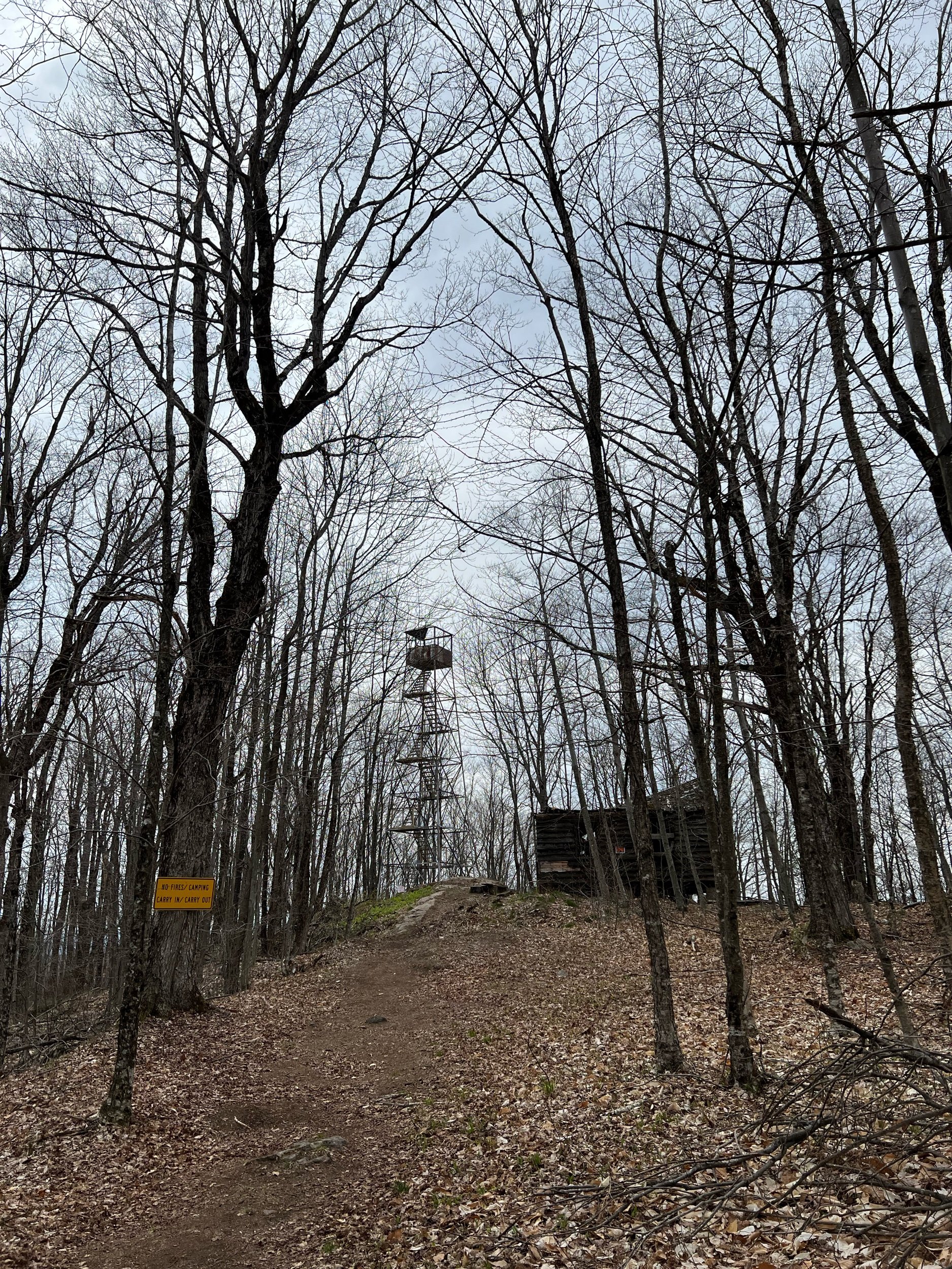
Once you park, you’ll cross over the barrier (same side as where you parked, behind the Swede Mountain signage) cross a small water area and climb a few well defined steps to pick up the trail. For the next mile to the tower, follow the signs and stay on the trail- and don’t worry, there will be signs reminding you most of the way to in fact, stay on the trail! (Which I don’t think I’ve seen anywhere else in the park, but correct me if I’m wrong!)
While there is no view from the summit, you’ll have 360 views from the top of the tower itself (when I visited, the cab was open.) Be mindful that it is a restored tower that is missing some of the window panes. As with any fire tower climb, be cautious, and know that it will (most times) be much windier than on the ground - hold onto your hats and belongings!
🚧I will add one note of minor caution: on your descent, there is one area to ensure you are following the arrows back to the trailhead. We were jogging down to the car and accidentally went straight instead of turning left where an arrow was placed. I believe the path we accidentally took used to be a truck road, which is why it didn’t seem totally off to us at first. But in the event you’re on a mountain high and miss the turn like we did, it’s no big deal (well, maybe a bit steeper…) to backtrack and get back on the defined trail.
Don’t forget to carry out what you carry in, avoid climbing the tower with microspikes, and remember that this trail backs up onto private land.
An ideal day and what you can pair this hike with:
nearby Bartonville Mountain (15 min. back towards the thruway; another nice hike with moderate elevation gain and mileage.)
Northern Tongue Range ~ 30 minutes south in Bolton Landing.