Mount Adams (Fire Tower)
October 24, 2020 | Newcomb, NY
I underestimated this hike in so many (good) ways!
The background: I was back in the ADK for my annual weeklong fall-cation and my friend Ely asked if I wanted to hike. So of course the answer was yes, but then came the bigger Q – where should we go?! That’s the great thing about the Adirondacks – the options and opportunities are endless. Loon Lake was our first hike together a month prior (so fun and steep and cold) so we went back and forth a bit between two options (not mentioning the other since this will come next year!) and landed on Mount Adams. She had climbed it before but thought it would make for a fun day, wasn’t too long, and would still satisfy my love for the beloved towers.
The weather forecast had predicted rain, but we didn’t let it stop us. We were going to have a great second hike date. I just knew it. (Spoiler alert: we did!)
The Fire Tower Challenge: For those of you who have followed along on my journey, you know how much I love the ADK Fire Tower challenge. The objective is to hike 30 mountains in NY state that still have remaining fire towers on their summits (25 ADK + 5 Catskills.) To technically “complete” the challenge and earn the patch, you only need to summit a total of 23 (18 ADK + 5.) I have 2 left in the ADKs to finish the challenge, but plan on completing all of them, as well as the ones that no longer have standing towers. I will write more on this in a separate post, but anyways, Mount Adams is said to be one of the tougher ones on the list (and I concur, now that I’ve climbed it.) Check out more info on the towers and the challenge, here.
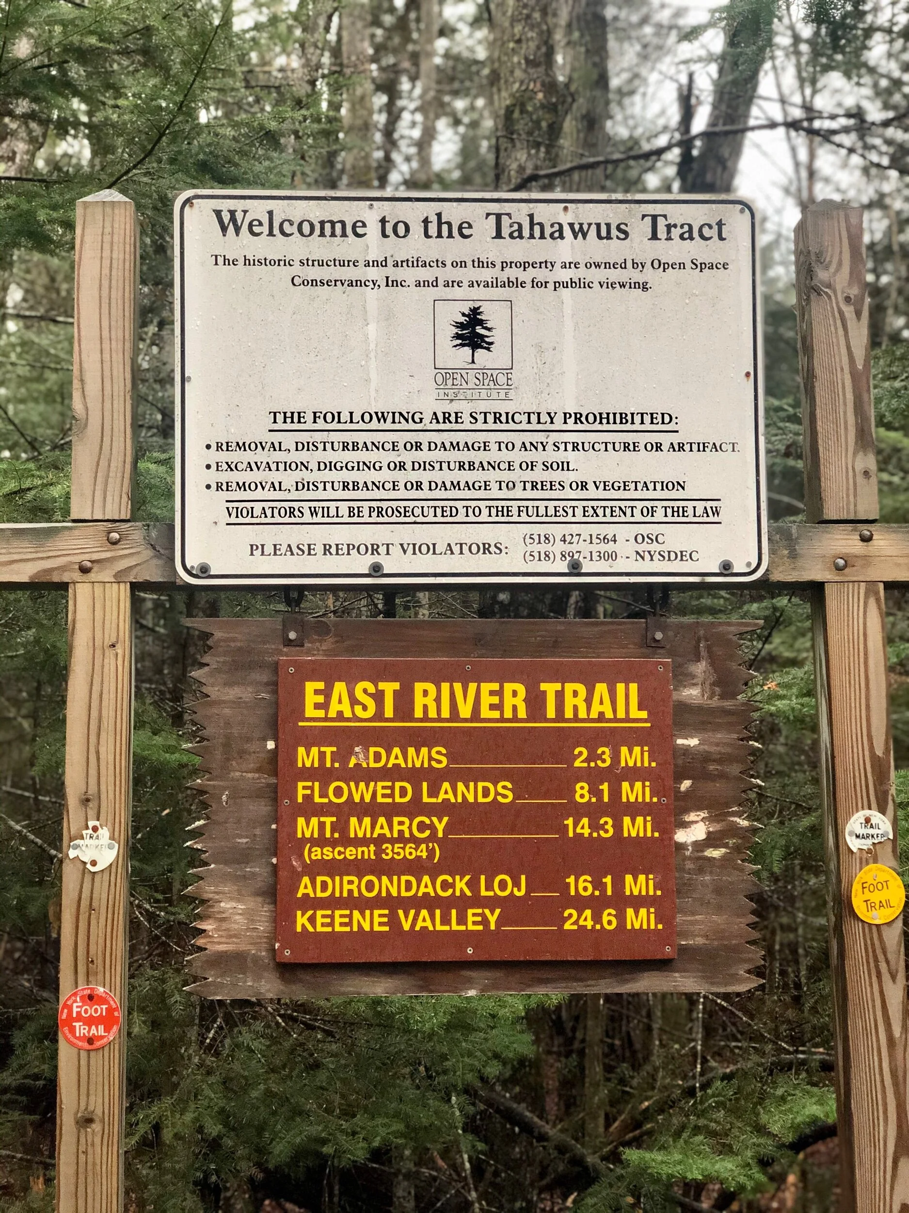
Getting there: This trailhead is on Upper Works Road, near the starting points for some of the High Peaks – in Newcomb, not in Lake Placid/ Keene Valley. From Bolton Landing, I hopped off exit 26 from I-87, and followed the GPS to Upper Works Road (in typical ADK fashion, there’s no AT&T cell service for most of this.) On Google Maps, it’s called “Fire Tower Trailhead” – this is accurate. You will go drive through some of an abandoned mining village, Tahawus (so much good history here, I won’t delve into right now) until the trailhead appears at your right. If you find yourself at the end of the road, you went too far. The good news is it says it’s the trail for Mount Adams (photo below) so you’ll know you’re at the right spot. This is also the lot for Allen Mountain, a very long, trail-less 46’er that I have yet to tackle. Your car should not have issues in 3-season weather (the Jetta did just fine) and the lot has room for a decent handful of cars. We hardly saw a soul (it was also a rainy Saturday past-peak foliage) so you should not have trouble getting a spot if you start early (or after the morning crowd.)
The route: To my knowledge there is only one maintained route out and back (unless there is a bushwack that I am unaware of.) This write-up is based on the one on the maps.
I followed Ely down the road in my car (we weirdly timed it perfectly) while it rained and rained and rained. Kind of more than I was hoping…but we were prepared. We parked, got our rain gear on, signed in, and went on our way at 8:08 AM. In 2.3 miles, we would reach the summit of Mount Adams.
The trail started out flat, and before we knew it, we approached the Hudson River, where we stopped to take some photos on the suspension bridge. Let’s just say this bridge made me a lil’ nervous running across it… but it was fun. We carried on until we got to Lake Jimmy, where we detoured for a quick minute so I could see it. The misty, foggy, morning created an eerie but cool vibe. We were there for it. We then looped around the lake, following the trail, still feeling some rain drops but carrying on. We then reached the former caretaker cabins that still stand -with a note from one of the former caretakers, an email dated from 2008- so cool! (see below in photos.) Shortly after, we reached the sign for the slight turn for Mount Adams. The East River Trail continues and takes you towards Allen, but you will be making the left as the sign indicates. From here on out, you’re going up.
The incline began, but we took our sweet time, trying not to slip and fall, and knowing we had nowhere else to be, except in this moment. I also realized at this moment it was time to put on my pack raincover. I had hoped the rain would pass, but it was relentless. I am grateful this happened though, because I never realized what an awesome neon green color it was! This was a bright spot (literally and figuratively) to the day. I requested Osprey to make a pack in this color, but I’m not sure they were on board… I’ll try again.
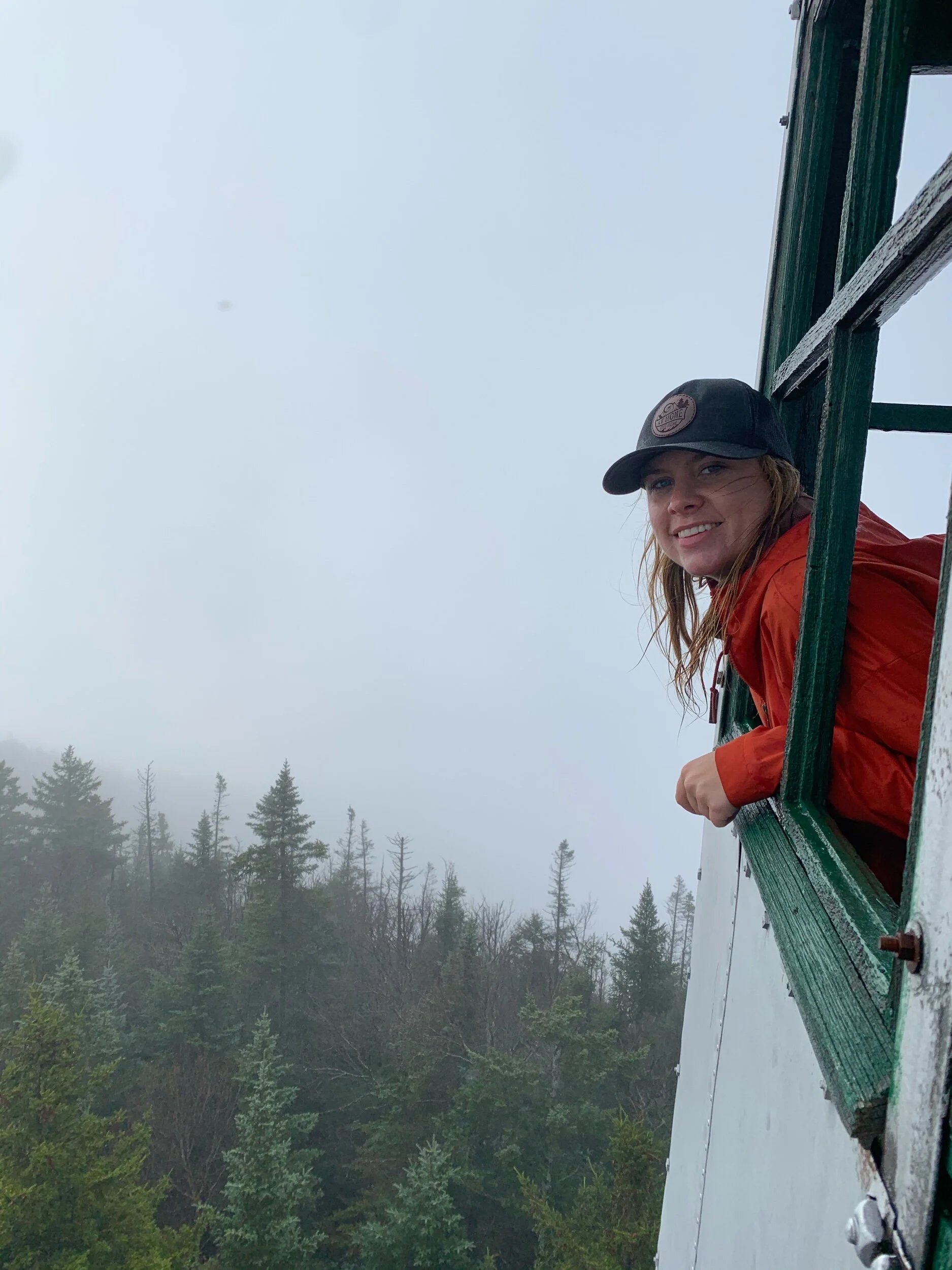
We passed by one woman on her descent, but that would be our only human encounter until our way down (there was no animal encounter either…) After much laughter, storytelling, and catching up, we finally reached the last section of (steeper) incline. The terrain is reminiscent to a High Peak, and you will be feeling it. After many cautious climbs up steep slabs of ADK rock, maneuvering around logs and trees, we knew we had to be close. Ely ran ahead and soon exclaimed we were there. I quickened my steps as the temperatures cooled, and there it was – the tower! We made it. As mentioned, this is a treed-in summit – the potential view is from the tower itself. We scurried up the tower steps and were greeted with, you guessed it- clouds. Lots of ‘em. The rain had stopped by this point, but we were totally fogged in. This was only my second time up a tower with no views (Hunter Mtn was the first a few weeks prior) and although everyone says the view is phenomenal, it was kind of cool to be up there in the clouds. It’s also another excuse to come back on a sunny, clear day. 😉 The howling wind turned us icy cold as we snapped foggy videos and photos – so we headed back down. After a quick snack, we began our descent, just as cautiously as we had ascended. The rain had let up at this point for good it seemed like, but we had a bit of a slippery ways ahead of us. A younger man was on his way up in a t-shirt (brrr) but he looked determined, so we exchanged short greetings and kept going. The way down was thankfully uneventful, and we continued our banter and laughed so loud you could probably hear us from Keene Valley. We felt accomplished and our spirits were high – as the sun finally started to come out on the final 0.5ish miles of our descent! Such is life…
Although I love the sunshine, I really loved that we experienced this hike in a different way through a different lens in the rain, fog and clouds. This was a reminder that it’s not always about the view and the perfect weather, but rather, about times where you push through obstacles and strengthen yourself mentally and physically. Not to mention, having upbeat company is everything (let’s hope Ely felt the same way lol...)
Concluding notes: While this hike isn’t impossible, you will be putting in some work! But it’s fun - there is truly a bit of everything. If you are new to hiking the High Peaks, this would be an excellent place to start. You get a feel for the terrain without being terribly far into the wilderness. I also feel as though it’s not one of the popular ones- we saw 2 other people the entire day (no wildlife sightings this time.) But in my opinion, it is one of the best fire tower hikes in the High Peaks region. You can quote me on that.
As always, do be extra cautious when it rains (or during any inclement weather for that matter.) We had some very slippery encounters, as you will 100% have to scramble up rocks and climb through steep sections. It should not deter you, just know this if you are going to go one day when it might rain. There is also no view at the summit, except from the tower. I no longer strictly chase views at this stage in my hiking career (though I do love them endlessly) and I knew there would probably be no view when I went– and there was not. But there is definitely something magical about being in the clouds, unable to see anything that lies beyond them…
I’ll be back to that same spot before I know it, since Allen Mountain is on the agenda. 😉
(and yes, Ely committed to accompanying me for that one, so stay tuned next year for that write-up…)
One more thing: I will note here I had more energy for another hike afterwards in the afternoon– so I parted ways with Ely and drove west to Owls Head Mountain in Long Lake. I write this in case you’re wondering if it’s possible to combine this with another hike… If I were to do this again, I would suggest maybe Goodnow instead since it’s a little closer (a nice, more aggressive summer day with lots of daylight, you could really hike all 3.) OR you could wander and explore Tahawus. I think that’s what I’ll be doing next time.
Until then…