The Southern Tongue Range
September 6, 2020 | Bolton Landing, NY
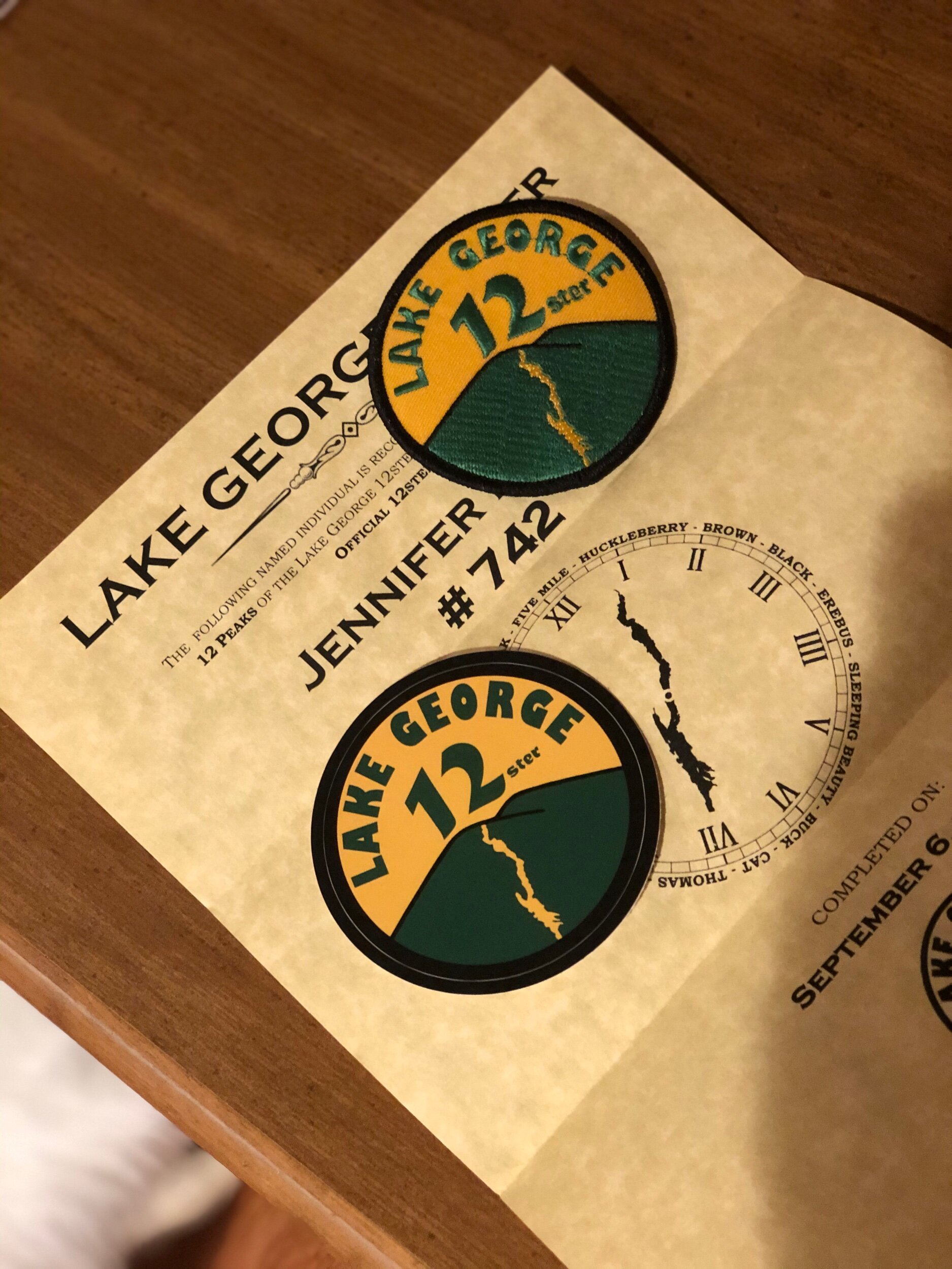
The background: This was day two of my solo Tongue Range expedition and would include the 3 mountains I had to hike to finish the Lake George 12ster challenge. I completed the Northern Range (details in separate post) the day prior with relative ease; however, I knew this would be the longer and more challenging day, so I had mentally prepared myself for what was to come. The weather forecast predicted another sunny and warm late summer day, so I knew it was my day to get out there!
Getting there: This time, I drove from Ticonderoga where I had stayed the night prior, so took 9N south – the trailhead is about 5 minutes (driving) past the Deer Leap parking area for the Northern Range. It will be exit 24 (Bolton Landing) if coming from the Northway. You will see a quarry with parking spaces next to it. You can also park in the lot, right next to the quarry (which is what I ended up doing.)
(As usual, AT&T cell service is sparse, but you’ll have some reception throughout the day in certain areas, for sure.)
The route: A loop starting at Clay Meadows, then on to Fifth Peak, French Point, and First Peak, finishing out with the trail along the Northwest Bay to loop back to the trailhead, a total of about 12 miles. After researching and reading about the route, I chose to complete the loop clockwise to tackle the peaks first, and then have a relatively flat (hmmm) walk back to the trailhead (what they really meant was a long, not-so-flat 5 mile “walk…”)
The start: I decided to start “later” than I normally do in the morning, after an investigation of the parking situation the day prior proved I should be fine to get there when I could; it would not be a -5AM or nothing- situation, as some areas in the ADK are. I arrived at 7:30 enjoying the cool morning temperatures that wouldn’t last and signed in at the trailhead by 7:45. You will walk behind the quarry area for the trail register (same side as parking lot and quarry.) I was still on high alert for rattlesnakes just like I was the day prior. Let’s see if any would say hi to me today.
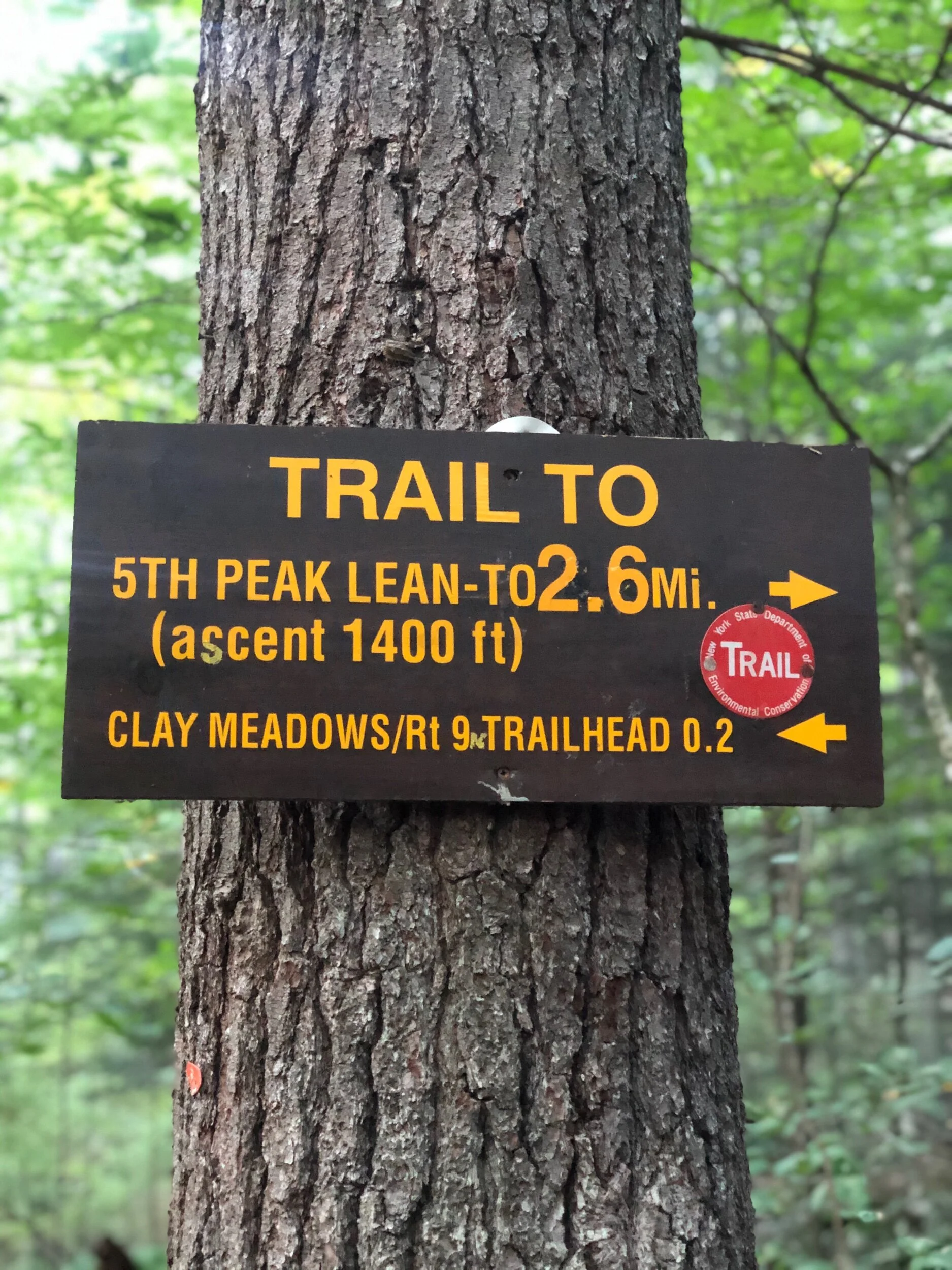
Fifth Peak
I began the 2.6-mile gradual walk through the woods, passing small but soothing waterfalls, and enjoying the calm before I would arrive at Fifth Peak, the first summit of the day. The trail is well-marked and easy to follow, with no surprises. You follow the signs up to the lean-to and summit, a few minutes’ detour from the main trail. I arrived at the lean-to in no time, said hello to the family occupying it, ate a quick breakfast snack, and continued down the mountain to head south to French Point Mountain. There was a bit of a view from here, but I knew that even more views awaited me.
French Point Mountain
After you get back on the trail after Fifth Peak, you will follow the trail (with no detours, bushwhacks, etc.) all the way to First Peak. About 1.6 relatively moderate miles later with phenomenal views all around and some very manageable scrambles, I made it to the second peak of the day: French Point. I stopped here to hydrate and take a few scenic photos of the lake (below), which to be honest, doesn’t even do the view justice. The lake looked surreal, dotted with her majestic green islands and tiny boats. It was also at this time I realized it was going to be a very hot day, and that hydration and fueling myself would be key. I still had a while until the last 5-mile trek along the Northwest Bay, so I would have to remain conscious of my exposure to the hot midday sun.
First Peak (and last peak!)
The next section had some more rock scrambles and rockier terrain than previously, but still nothing impossible in my eyes. It was a gorgeous day and I hardly saw anyone, except for a few hikers here and there. It was a nice reward to be able to see the mountain ahead that I would be climbing. Still no sign of any rattlesnakes, and I promise you I remained vigilant!
Before I knew it, I saw the FIRST PEAK sign – I had now arrived at my last peak of the day and last of the Lake George 12ster challenge! I spent a few (but long) moments hydrating, eating the rest of my food and reveling in my finish before carrying on the trail. I still had a long way ahead of me back to the trailhead, and the heat was starting to really get to me at this point. My initial plan had been to possibly venture to Montcalm Point, which is about a 0.4-mile detour from the trail at the very tip of the Tongue. However, I made the decision to bypass it at this time, as I feared I would run out of water or feel even worse from the heat if I detoured too far. After First Peak, the trail was moderately steep as I began to lose elevation and make my way back into the woods.
After bidding farewell to the views of Black Mountain across the lake and the various smaller islands, I finally found myself in a tree-covered area, relieved to be out of the sun for a bit. I then saw the sign I had been waiting for, which confirmed the mileage I had left in my trip – 5 miles back to Clay Meadows. Oh My.
I really wanted to enjoy this section along the lake – it was so peaceful, as the water lapped along the shore and voices were heard on nearby docked boats. But I also badly wanted to be carried away on one of the boats and then dive into the crisp lake water. I was pretty exhausted by this point and could not wait to take off my boots and cool down. But I kept going, albeit slowly, stopping only once to splash water on my face and take a minute to enjoy the views of the bay. Despite what you have read or heard, while this section is not steep nor rock scrambly, it is also not entirely flat. You will weave in and out of the woods with the shoreline, faced with a few hilly areas here and there. You are not out of the woods on this one until you are – well, out of the woods. I only saw one group of people heading towards Montcalm Point, and still – no rattlesnakes (or any other animals, for that matter) approached me. When I finally saw the trail sign at the end for the last 0.2 miles to the Clay Meadows parking area, I was relieved – it had been a long, hot day, and I had a 4 hour drive ahead of me to get back home. But my mission had been accomplished.
Concluding notes: What. A. Day. This is a spectacular Lake George mountain range that I cannot recommend highly enough. The views are outstanding- you see where you are going most of the day ahead of you. The Queen of Lakes is in your sight most of the day and the hike along the Northwest Bay will provide a soothing soundtrack to your exit (or start.)
That being said: it is not a beginner hike, nor a short one. You will be working for quite a bit of mileage and climbing as you make your way down the spine of the range (or up, depending which way you go.) From what I saw, there aren’t really any water sources, so be prepared with what you need for the day. You are also exposed on the ridge often, so be wary of this should you choose a day with extreme temperatures. In the heat of the summer, (in addition to lots of water) be sure to bring your salt tablets, sunglasses, hat, sunscreen etc. I also hardly saw anyone the whole day -- and I went Labor Day weekend. I’m not sure how crowded it normally is, but I strongly believe this is a rewarding and challenging alternative if you wanted to avoid the more populated High Peaks region on a given day.
I felt entirely comfortable completing this range solo – but had there been hazardous conditions (like any hike, really) I may have felt differently. I have also completed many High Peaks alone and have learned to understand my limits.
In addition, I did not see a single Timber rattlesnake; however, this is a known habitat and they are out there – be wary where you step and where you place your hands. Give them a wide berth if you should see one. That being said, you should have no issues if you give them space and leave them to do their thing.
As a reminder, only camp at designated sites or stay at the lean-tos. Carry out what you carry in. Plan your route, have a source of illumination (non-cellphone) and clothing layers should you be out longer than expected. And lastly, be sure to soak in every second of this classic Lake George range! I can’t wait to return one day to check out Montcalm Point, and to hopefully hike the entirety of the Tongue in one trip!